Paddling the Green River through Canyonlands National Park

In the summer of 1869 a one-armed Civil War veteran named John Wesley Powell put together a ten-man expedition to explore and chart the Green River and Colorado River from Wyoming to the Grand Canyon. Over 99 days and close to 1000 miles, he and his men navigated unmapped canyons and plunging rapids, enduring searing heat, the destruction of one of their four boats, the dangers of rattlesnakes and rock slides and scorpions as big as a hand, and the loss of most of their hats to violent winds and waves.

Maj. John W. Powell

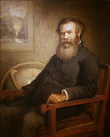
The trip was not without its controversies—several of Powell’s biographers have made light of evidence that the major was a bit loose with the facts of the journey, and that he suppressed any publication of rival trip reports by his men. More controversial is the fate of the three members of the party who, just 80 miles or so from the end, decided to abandon the expedition, leave the river, hike out of the canyon, and set out across the desert for a Mormon settlement. That they died a horrible death is certain, though whether by thirst or by Indian attack (in a case of mistaken identity) is still debated. More questionable still is the fact that Major Powell, upon reaching the end of his expedition and returning to Washington D.C., never sent a search party to look for the lost men, nor even inquire after their fate.

Notwithstanding the critiques of Powell himself, his expedition remains one of the great achievements in American exploration. The historian Wallace Stegner called it “the second opening of the West,” after Lewis and Clark’s adventure. The last major blank space of terra incognita on the American map was filled in, not to mention the contributions to geology, biology, geography, and meteorology that the expedition yielded.

Drawn in by Powell’s harrowing adventures and vivid descriptions of the desert, and intrigued by the prospect of canoeing through Utah’s famous Canyonlands, our party embarked on a 56-mile (90km) slice of river adventure, meager by some standards, but just fine by ours. After all, it was June. In the desert. And we had no intention of having to quit and walk out.

IMG_2632
Sunrise over the Colorado River near Spanish Bottom, Canyonlands National Park


When thinking of these rocks one must not conceive of piles of boulders or heaps of fragments, but of a whole land of naked rock, with giant forms carved on it: cathedral-shaped buttes, towering hundreds or thousands of feet, cliffs that cannot be scaled, and canyon walls that shrink the river into insignificance.
John Wesley Powell, 17 July 1869, along the Green River north of the confluence with the Colorado River


In a Nutshell
Nights: 4
Paddling distance: 56 miles (90km)
Portages: 0 (That’s right, I said zero!)
Outfitter: Tex’s Riverways, Moab: canoes, paddles, water jugs (6 x 6.5 gallons), portable toilet, fire pan (never used), drop-off at Mineral Bottom, and jet-boat exfiltration back to Moab.
Paddlers: The author, curly-bearded rock-hopper from Toronto, and three Texans: Mike, master photographer and logistics champion; Dave, marathon runner and optimistic father of teenagers; and Michael, canoeing rookie and laundry enthusiast.

Mud flats at Bonita Bend, Green River, Canyonlands National Park


DAY 1: A determined engineer with a wicked sense of adventure is no doubt responsible for the section of Canyonlands’ White Rim Road that plunges over the edge of a mesa and drops 1000 feet to the river below, with a dozen or so switchbacks desperately cleaving to the side of the cliff.

At the bottom of that cliff, at a place called Mineral Bottom, we pushed off in a pair of 17-foot aluminum canoes in the mid-morning white glare. We launched just ahead of a party of 25 or so teenaged rafters and their guides, who planned to float the Green River lazily for four days before shooting the famed Cataract Canyon and its 75 sets of whitewater rapids. Our itinerary would stop us just short of that goal, though this wouldn’t be the last time we saw the kids.

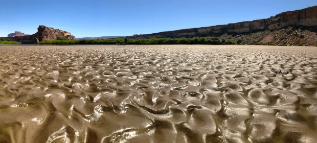
Paddling moderately along the Green River’s swift current, with the torch-red sandstone of Labyrinth Canyon towering high above us, we made the 11 miles (17.5km) to Fort Bottom in a little under three hours. Along the way we stopped at a sandbar island to gape at the natural amphitheatre forming in the cliffs opposite Point Bottom.

Fort Bottom is a broad plateau of desert scrub forming a bowl beneath the sweeping rim of the canyon. There are ample spots for tents, though little shade. We spent much of the afternoon in the shadow of a tiny four-man alcove, and the temperature held at 90°F where in the sun it was 104.

After waiting out the afternoon’s heat, we marched up to the Fort Bottom ruins before sunset, a twenty-minute hike to a promontory overlooking a 360-degree panorama of the bending river. We scrambled about the 800-year-old ruins of a Puebloan watchtower, and watched Dave jog up the Fort Bottom trail almost to the White Rim Road just before the sun fell below the rim to the west. We lost sight of him for awhile, and feared he’d slipped off the scree, so Michael and I took the med kit and trotted after him, unnecessarily worried, until he appeared, exhilarated and unhurt, from around a hidden bend.

Following a dinner of steak fajitas and single malt, we watched the stars emerge in a moonless sky and welcomed the local bats on their evening bug-eating sortie. I commenced reading Edward Abbey‘s Desert Solitaire, which he wrote in the early 1960s after serving a brief tenure as a ranger in nearby Arches National Park. Mike prepared his tripod to shoot the Milky Way, enlisting the others’ help to light the tents during the long exposure. The first night in the backcountry is always a late night–we’re too excited to sleep.

Paddling distance: 11 miles (17.5km)


“The desert is made first and foremost out of light, at least to the eye and the heart, and you quickly learn that the mountain range twenty miles away is pink at dawn, a scrubby green at midday, blue in the evening and under clouds.”
Rebecca Solnit, A Field Guide to Getting Lost

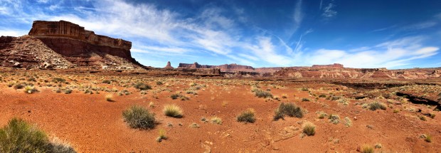
DAY 2: Sunrise struck the Fort Bottom bluffs with diagonal streaks of orange light, and before long the heat of June compelled us to return quickly to the relative coolness of the river. We paddled our way around the bend and hauled down the 3-mile straightaway of Potato Bottom. On our left flank the sandstone gave way to bulbous limestone formations overhanging the water, providing some shade from the fast-rising sun.

With the mercury soaring the term of the day became “evaporative cooling”—frequently we soaked our hats, bandanas and shirts into the water to chill our skin. Around the bend at Beaver Bottom we spotted a small notch in the cliffs with a triangular beach in full shade, and we pulled over for a snack break and some low-level rock climbing.

Later, while paddling around the flank of Millard Canyon the ballyhooed Buttes of the Cross came into view, so named by Major Powell for their cruciform appearance high above the river.

We had planned to stop for a midday hike in the horseshoe canyon at Anderson Bottom, near Bonita Bend. But the teenage rafters had overrun the prime landing spot, and with the sun bearing down on us from its noon peak, we decided to push on.

Around the bend at Valentine Bottom an enormous cleft appeared in the 600-foot wall to our left—a peek into Holeman Canyon, another reputed hiking spot. Beyond this bend, Labyrinth Canyon officially gives way to Stillwater Canyon, and the change is apparent in the rock formations. Above the ochre sandstone walls a hundred-foot-tall “bench” of limestone lies like a thick layer of white icing on a red-velvet cake.

The heat bore down on us, and Michael took the opportunity to dry out the laundry he’d done in a large Ziploc bag with an agitation of Dr. Bronner’s peppermint soap and river water. This earned him the nickname “Spin Cycle” for the remainder of the trip.

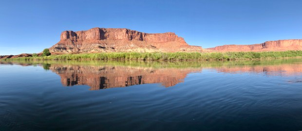
We took a short, buggy break among the desert willows on a beach opposite the famed Millard Canyon Benches, and then powered on to Turk’s Head. This unmistakable natural tower is formed by a three-mile erosion of the limestone band, separating Turk’s Head from the rest of the canyon wall.

Turk’s Head (left) and the plateau above the Green River

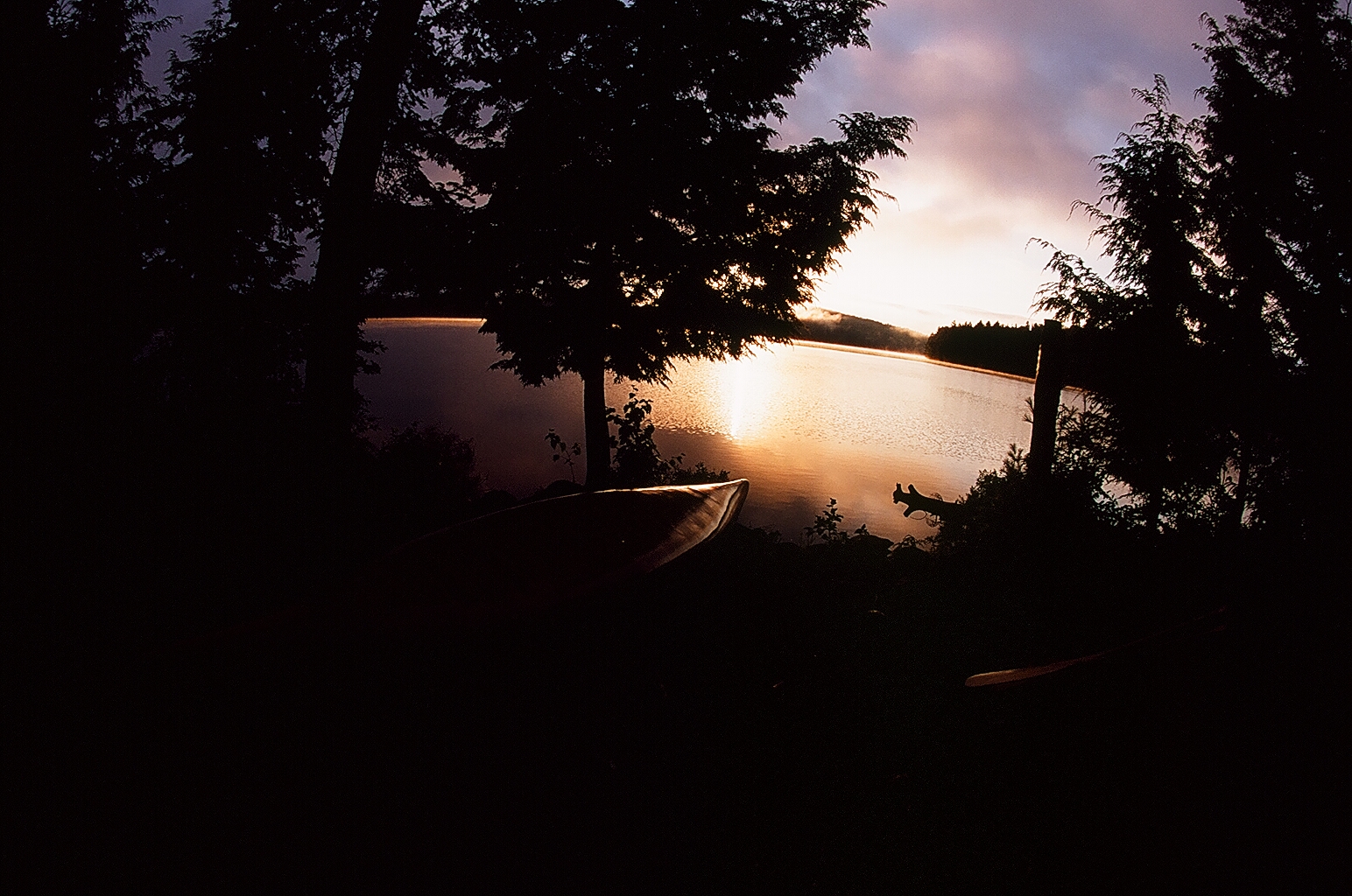
Three-quarters of the way around the bend lay an exquisite campsite on a bluff above a bench of hard white sand, partially shaded by the cliffs. A twenty-mile morning of paddling came to a close with a cool swim in the swift current, after which we waited out the afternoon heat in the shade.

By 5pm the sun had waned enough for us to begin the scramble up the 100-foot cliff to the Martian landscape of the Turk’s Head plateau. Above the plateau, Turk’s Head itself towers another 300 feet, and we scrambled most of this elevation over red-and-white talus until we reached the nose, beyond which we could not hope to climb without ropes and protection. As the pinks and yellows of sunset began to appear in the sky, we could see a full-circle panorama of the river bend, the canyon walls, the expansive mesas, and the distant, isolated buttes beyond Deadhorse Canyon.

Later, from our campsite on the ledge over the river we gaped at the afterglow of the sunset lighting the easterly clouds, and again the bats whirled among us hunting insects. Despite the lingering heat we crawled into the tents around twilight, pleasantly aching from the toil and the sun, and passed out.

Paddling distance: 20 miles (32km); cumulative 31 miles (50km)


“The river itself sets the tone: utterly relaxed, completely at ease, it fulfills its mighty purpose without aim or effort. Only the slow swing of the canyon walls overhead and the illusory upstream flow of willows, tamarisk and boulders on the shore reveal and indicate the sureness of our progress to the sea.”
Edward Abbey, Desert Solitaire

DAY 3: Another sunrise exposure compelled us to pack up camp swiftly and peel off onto the river by 8am. Today the thermometer would reach 109°F, the highest of our five-day expedition.

Our goal of the day was 16 miles to Water Canyon, but the absence of a good landing and the presence of another canoeing party obliged us to paddle on to Powell Canyon; thus another 20-mile day.

Along the way, the walls of Stillwater Canyon became narrower along the river, providing us with some shade along the left bank for the first couple of hours. A blue heron, or possibly several different blue herons, journeyed just ahead of us, always launching itself into a low glide just before we could bring it squarely into the frames of our smart-phone lenses, as the DSLR zooms were stowed in dry bags.

We made fast progress over the 12 miles down to Jasper Canyon, where we stopped for a snack break, a short hike and a brief swim. The awesome waterfalls of Jasper had already dried up for the summer, but we still marveled at the colossal cliffs and what remained of the green hanging gardens.

Bend in the Green River seen from the mouth of Jasper Canyon

After another 5 miles we arrived at the mouth of Water Canyon, where a narrow side stream emerges to meet the Green River. Paddling up this creek we found another canoe party eating lunch in the shade of the cliffs, and though there was a decent campsite just beyond them, we didn’t feel like stopping here, and so we paddled back out and continued down river.

At Powell Canyon just before 2pm, we beached our gear and dove into a cliffside alcove for lunch—grapefruit and blueberries, plus the last of our cheese and salami—and a nap in our camp chairs. Around 5pm, the teenage rafting party whirled around the bend in the swift current and literally bumped into the rocky ledge below our campsite. They’d hoped to camp here too, but the flat spots were too few for an expedition of their size, and they pushed on for the Confluence. One of the overarching lessons of paddling the Green River in high season, in addition to evaporative cooling, is to choose your prime campsites by early afternoon or risk settling for lesser spots. There are more than two dozen campsites along the route, but they (and the hiking opportunities they afford) are not created equal.

Eveningtime we scrambled up the side canyon above our tent site hoping to find a breach in the overhanging band of limestone. We dared not climb the attractive cracks exposed to a fall of twenty feet or more, so instead we traversed over to Powell Canyon and hiked about halfway up its shaded grooves, rife with cedars and prickly pears, before the approaching dusk begged us to turn back.

We made falafel burgers for dinner and leaned back in our chairs, craning at another starry sky and wishing the desert heat to dissipate before we had to crawl in the tents. After dark, I walked up by headlamp to the spot where we’d stashed our dry bags, and found a black widow spider had spun herself a web in the alcove. Startled and instinctively deferential to venomous creatures, I wheeled about and left her to her nocturnal hunting.

As we sat in our camp chairs slowly sinking into the soft sand we all agreed we should probably know more, by this stage in life, about the cosmos and constellations and the like. Perhaps once we did know, only now our intelligence has become so localized that we can no longer remember. Perhaps we never needed to know until now.

It was a new moon, the darkest night in one of the darkest places in North America, and the night was bountiful. Mike set his internal alarm to 2a.m., the darkest time, and captured the sky for thirty seconds at 1600 ISO.

Paddling distance: 20 miles (32km); cumulative 51 miles (82km)

Starry sky and Milky Way from Powell Canyon, Green River, Canyonlands National Park (Photo by Mike Roberts, astrophotographer)


“The boaters floated on a serene current meandering through a vast assortment of rock formations high above—buttes, pinnacles, turrets, spires, castles, gulches, and alcoves of all kinds. These perpendicular cliffs of Navajo sandstone—with their red, amber, and chocolate layers—were curiously stained with jet-black sheets and streamers of desert varnish.
Cecil Kuhne, River Master: John Wesley Powell’s Legendary Exploration of the Colorado River and Grand Canyon

DAY 4: After breakfast—our standard fare of peanut butter and peanut M&Ms on a bagel—we had just a short one-mile paddle to the Confluence of the Green and Colorado Rivers, where we pulled over on the long beach on the right shore as the teenage rafters were just breaking their camp. We scrambled up the scree and talus to a promontory offering a panorama of the two rivers becoming one.

The Colorado River was thick with rafting and canoe parties, and everyone was compelled to stop at the campsite register about two miles below the Confluence. Most of the rafting parties were sallying onward into Cataract Canyon, and so despite the congestion we were able to sign up for our preferred campsite at Lower Spanish Bottom, at the base of the Dollhouse Trail.

The final two miles of canoeing were the windiest of the trip, as the upriver breeze gained speed across the flat, mile-long plain of Spanish Bottom. Access to our campsite was up a steep bank, more than 10 feet high, and after tying our bowlines to willow roots we hauled up our entire outfit in the style of a bucket brigade. I slipped while helping Michael out of the canoe and quickly found myself neck deep in the water just six inches from shore, such is the drop-off.

The teenage rafting party was already docked for their afternoon hike up to the Dollhouse, an ethereal formation of caves, pillars and ledges atop the cliffs rising 1200 feet over the river. We enjoyed the broad shade of a cottonwood tree, under which we erected our hammock and camp chairs, waiting out the hot afternoon in a surprisingly strong and constant wind, which blew about our site. I felt free to read another eighty pages of Desert Solitaire while the others discussed and tied all sorts of fascinating knots.

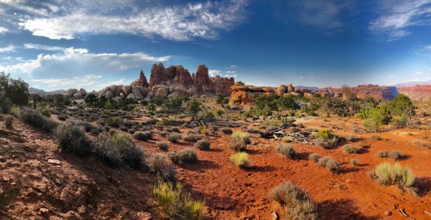
After the rafters returned and embarked at last for the rapids and we saw them no more, we packed up a few snacks and water bottles and began the ascent of the Dollhouse. Along the steep trail, the vistas of Spanish Bottom and the distant bends in the river were nothing short of spectacular, but they almost paled in comparison to what awaited us at the top.

There is no more fitting end to the expedition than to reach the Dollhouse, especially at sunset. The views northward and westward into the Maze of Canyonlands, and southward and eastward into the Needles, transfix the tired hiker and hold him in a state of awe. The Dollhouse itself is a repository of narrow cracks and enormous fins of rock, and here we bouldered, hollered and scampered like children, careful not to trample any of the delicate vegetation, until at last the onsetting dusk bade us descend back to Spanish Bottom and cook one last dinner in the desert wilderness.

Paddling distance: 5 miles (8km); cumulative 56 miles (90km)


“The exploration was not made for adventure, but purely for scientific purposes, geographic and geologic.”
John Wesley Powell


“Wilderness is not a luxury but a necessity of the human spirit, and as vital to our lives as water and good bread.”
Edward Abbey

DAY 5: In the morning we lazed over multiple cups of coffee as a pair of mule deer does grazed nearby on some cottonwood leaves. We packed up our gear and awaited Tex’s jet boat, which arrived just before 11am to zip us and a few other canoe parties 50 miles up the Colorado River to Potash Landing, just short of Moab. The journey took two hours and was a breezy blur of ever redder and more spectacular canyons and cliffs, and as we motored onward the rushing winds made whitecaps on the water.

Our skin was caked with a week’s worth of sand, which no amount of swimming could adequately remove, and cracked from the brunt of the desert heat. Those of us still maintaining hair found it tangled and semi-bleached, and the sandal-shaped tan lines on our feet bore evidence of the daily battle with the sun. Though we never ran out of water we were still possessed of a deep thirst, which we quenched in town on sodas and beer before a sufficiently gluttonous post-trip feast at a Moab restaurant.

At sunset we ambled along the town’s sidewalks eating ice cream and stretching our backs. We stopped in at a local bookstore, where behind glass they keep a first-edition copy of Major Powell’s original account of his 1869 expedition. The clerk was delighted to show it to us; its large, gold-rimmed pages contain the serifed descriptions and illustrations of that original Green River exploration, though not one of us was prepared to part with the $2750 it would take to purchase the book. Better to hold the priceless experience of our own adventure close to our hearts.

In a chapter of Desert Solitaire, Edward Abbey and a companion paddle down a section of the Colorado River upstream of the construction site of what would become the Glen Canyon dam. His goal is to explore the canyons one last time before they are lost to the reservoir, and his voyage is a silent protest to the engineers and bureaucrats. He writes:  “A civilization which destroys what little remains of the wild, the spare, the original, is cutting itself off from its origins and betraying the principle of civilization itself.” Much like John Muir, Abbey believed wild spaces should exist and thrive for their own sake, but Abbey also worried that the tides of industrial greed, overpopulation, and easy access would inevitably swamp the wilderness. As such this chapter of his book, so nearest our own experience, reads like an elegy, which tempers the delight of finishing an awesome trip like the Green River paddle. That’s probably for the best; one ought not take the wild–even a simple 5-day slice of it–for granted.

Tips:
A few things that might make a great trip better:

In addition to the regular outfit of canoe-trip gear, we found the following things useful to bring to the desert:

  • More sunscreen than you think is possible
  • Long-sleeve shirts with SPF protection
  • A back-up hat (heed the lesson of Powell’s mutiny)
  • Extra lip balm and moisturizing lotion
  • A cooler with ice, plus a wet towel draped over the cooler
  • Enough water to quench an elephant’s thirst—we drank/used almost two gallons per day per man, and were glad to have more than 6 gallons left over at the end of the trip

IMG_5918

All photos copyright © 2018 Richard A. Johnson, except where noted.

Mount Mitchell Trail Run

Like too few great mountains, Mount Mitchell was named after a stubborn preacher. Elisha Mitchell was an ornery man—it took a certain kind of uncompromising mulishness to measure mountains, especially in those early days of vertical exploration. Sir George Everest, for one, was renowned on two continents for his stubbornness. I imagine the pursuit of trigonometry will test a person’s obstinacy, much like the pursuit of the Almighty will test his patience for the unknowable. Perhaps that’s why the Reverend Mitchell found his avocations at high altitudes—whether mapping peaks or communing with God, his determination knew almost no limit. Almost.

In 1835—by then a seasoned geographer and surveyor already in his forties, and also a Presbyterian minister—Elisha Mitchell spotted a peak above the clouds in the eastern Appalachians and estimated it was the highest in the land. He spent the next nine years measuring and re-measuring it, between his Sunday sermons, until he was satisfied the mountain had no equal in the young United States of America. Even the venerable Mount Washington, named for the near-mythical Founding Father, fell in its figurative shadow.

Such a towering blasphemy, even one rooted in mathematical proofs, offended the orthodoxy. A wiry senator named Thomas Clingman—later General Clingman of the Confederate States Army and the defeat at the Battle of Goldsborough Bridge—disputed Mitchell’s claim to have measured the mountain so accurately. Clingman fancied himself an amateur geographer (he had once been a student of Mitchell’s) and dismissed his teacher’s discovery. The two men fought a war of words via the newspapers until Mitchell punted and went back to his mountain, at the notably stubborn age of 63, to measure it again.

And there he died—felled by a sudden gust of wind, perhaps, or simply a loose rock, which caused him to tumble from the top of a cataract and plunge desperately earthward. But his stubbornness lives on at the highest of altitudes—indeed, the highest in all Appalachia, as later science confirmed—as the mountain was given his name.

And in stubbornness of one kind or other, we continue to climb it.


The Trail Run:
A late-winter ascent of Mount Mitchell via the Mt. Mitchell Trail
18km (11.2 miles) round-trip
Elevation gain: 3700ft
Summit temperature: -6C (-15 wind chill)
Time: 4 hours
Nearest town: Asheville, North Carolina

With a twist:
Due to winter closures on the Blue Ridge Parkway, I ran the mountain in reverse—from top to bottom, and then back up. The Parkway was open as far as the State Park, where a paved road leads to a summit observation tower. This, in hindsight, was much more enjoyable—once I started to climb, I was already warmed up from the descent.

Drive a fun car:
The access route along the Blue Ridge Parkway is perhaps even more exhilarating than the mountain hike, especially at dawn on a cold, clear day, with a car that handles curves nicely. Check for road closures in winter.

More info:
Trail Map
Mount Mitchell State Park
Mount Mitchell Live Weather & Summit Cam
Summit Post trail description
Hike WNC trail description


Text and photos by Richard Alexander Johnson

Paddling the Powell Forest Canoe Route, British Columbia

The broadest perspective on the Powell Forest Canoe Route is the one from the top of the mountain in the middle. Here, on the summit of Tin Hat—nearly 4000 feet above the Salish Sea, on a typically cloudless late summer day—you can take in a 360-degree panorama of the canoe circuit below you: large Lois Lake to the south reflecting the humpbacked Mt. Troubridge; silver-blue Horseshoe and Dodd Lakes to the southeast; the gem of Windsor Lake hidden behind a forested ridgeline to the east; Goat Lake bending around the horizon under snow-topped peaks to the northeast; and breezy Powell Lake to the north, curving around the tip of the provincial park, disappearing beyond another mountain, and reappearing to the southwest as it empties into Powell River.

And pockmarked across your magnificent vista: clear-cuts—forest circles, machine-torn land—woven by dusty logging roads that give the impression of blood vessels coursing through a tumour. This land is a beautiful tranche of Pacific Northwest rainforest. It is also a breathing, pulsating, chainsaw-roaring timber farm. The aroma on the air is glacial dust and distant sea salt, but the flavour of the forest is lumber.

Tin Hat Mountain—which our party climbed after completing a 109km loop journey through the lakes of Powell Forest—is named for the headgear of the early (safety-conscious) loggers who harvested these trees. But this wilderness now wears many hats: recreational, industrial, historical, environmental, aesthetic. It’s complex—to call it the opposite of how wilderness is often portrayed. And the fact that we stand on the traditional territory of the Tla’amin (Sliammon) First People, ceded to the Crown in a recent treaty, certainly doesn’t make it any less complicated.

In this beautiful, complex place we found ourselves on another Canadian canoe adventure: The Powell Forest Canoe Route, Sunshine Coast, British Columbia, July, 2016.


The Nutshell
Nights: 8 (including the last one atop Tin Hat Mountain)
Paddling Distance: 109km (the traditional route is about 65km and takes 4-5 days)
Portages: 6
Portage Distance: 7.5km
Mountain Hiking: 14km (round trip)
Mountain Elevation Gain: 2500ft
Outfitter: Mitchell’s Canoe & Kayak in the town of Powell River; lightweight canoes, paddles, PFDs and a shuttle service up the logging roads to and from the lakes.


Before you go travelling,
Before you cast off,
You thank the one who looks after us all,
He will be watching over me when I cast off.
–Tla’amin invocation, as told by elder Elsie Paul in
Written as I Remember It

DAY 1: We opened with a short, 5km late-afternoon paddle after driving up the coast from Vancouver and picking up provisions in town. We were four: Mike and Dave, amphibious rednecks from Texas; and Dean and me, insufferably patriotic Torontonians.

Christie, the amiable and detail-oriented proprietor of Mitchell’s outfitter, drove us down a logging road to the southwestern corner of Lois Lake and tipped us toward a primitive but magnificent campsite on an island where the lake widens. There was no picnic table at the campsite, but there was a broad beach encircling the island studded with statuesque stumps and deadheads—sun-bleached tree trunks towering out of the water, marking the extent of the forest before the lake was dammed and flooded. A warm, night-long breeze and a pink-and-peach sunrise energized us for the expedition ahead.


DAY 2: We paddled slowly out onto the wide expanse of Lois Lake, trolling our fishing lines behind the canoes. Under our hulls: a theatre of fish. There’s a hatchery on the north shore of Lois, and fish farms buoyed in the centre of the lake. Sure enough, before we were halfway to the eastern shore we’d hooked a pair.

Our brief morning on the water—only 11km to our next campsite—was at its best when a bald eagle swooped from an unseen nest and harvested a trout from the water, while somewhere in the woods of the south shore a chainsaw or industrial feller could be heard.

We navigated our way from Lois into Khartoum Lake, through a narrow, winding canal guarded by deadheads, several of which were eerily topped with eagle eyries. Beyond, Khartoum Lake presents like an inland fjord, with steep escarpments of conifers towering above each shore. A small cove on the north shore holds the lake’s only campsite (which was occupied, so we made camp on the beach next to the campsite).

Khartoum is an extra appendage off the regular Powell Forest route, but we found it worthwhile to explore. After setting up camp and napping, Dave and I paddled to the eastern end of the lake—an easy 5k each way—and caught a dinner-sized cutthroat trout for our efforts.

Cumulative: 26km paddling; 0 portages


Sweet sleep, come to me,
Underneath this tree.
William Blake

DAY 3: Khartoum Lake was absolutely still and a silent curtain of clouds gently glided over the mountaintops. The morning was saturated green. But when our paddling returned us to Lois Lake, back through the deadhead channel, we felt the rush of an easterly wind in our faces. It started to drizzle and—to add superfluous drama—we discovered a strong current working against our progress. It was a gritty three-hour paddle to the portage on the far northwestern shore, and the eagles watched us as we went slowly by.

The portage from Lois to Horseshoe Lake is practically manicured—a 1.7km stroll in the woods alongside a roaring creek. The rain let up (it would never again return), and we enjoyed our third meal of the day (we averaged five) before pushing out onto Horseshoe (probably named before the advent of aerial photography).

Flanked by low hills covered in cedar and fir, Horseshoe was bright and warm and remarkable for being the only lake from whose waters we didn’t hear the sounds of logging. Thus the logjam blocking access to the portage trail on the lake’s northern shore was a bit ironic.

From Horseshoe the Powell Forest route diverges. Paddlers can choose between the northwest portage route via Nanton and Ireland Lakes, reputedly easier but noisier (nearby is the jugular of the logging-road network, and Nanton Lake’s campsite is popular on weekends with locals); or they can choose the northeast route, pond-hopping in solitude, as we did.

Our reward for the 1.6km uphill slog from Horseshoe to Little Horseshoe Lake was our first taste of old-growth, with giant ferns carpeting the forest floor beneath thick red cedars, hemlocks and alders.

“Looks like ya gotta lil’ hitch in yer gitalong.”
One Texan to the other; roughly translated from the redneck as “It appears that the portage beat the hell out of you.”

Loaded down with our camping outfit, tons (almost) of camera gear, two canoes, and a food barrel heavy enough to sink a barge, the Little Horseshoe portage nearly crushed us. But on the far side we found it was just a short paddle to a warm campsite. We swam in the lake and photographed frogs and giant slugs and glistening sundews—a relative of the Venus flytrap—in whose habitat we made our camp.

Cumulative: 44km paddling; 2 portages


“Their canoes were small, with projecting prows, and dug out of one piece of timber, each with four or five small thorts, and some had their outside ornamented with rude figures painted with red ochre. Their paddles were short with round handles and pointed blades.”
Dr. Archibald Menzies, physician of the HMS Discovery, upon making his first contact with the Coast Salish Peoples in 1792

DAY 4: By now we’d lost count of the eagles, and the days were only getting hotter. We paddled and portaged our way from Little Horseshoe via Beaver Lake (a pond, really) to Dodd Lake, a quiet 7km paddle in a long green bowl. Now and then we caught a glimpse of snow-topped mountains through gaps in the hills on the eastern and northern shores, conferring a sense of entering the mysterious middle of something. And to the west, briefly, we saw the summit of Tin Hat behind a ridge.

At the top of the lake: a lonely cabin, with a dock and a diving board; no such place should be empty on a beautiful day like this, but we were almost disappointed to discover that it was. Just then, though, our solitude was broken when we neared the portage trail and saw eight large, heavy, red canoes piled on the dock. A pack of droopy-shouldered teenaged summer-campers emerged from the forest carrying enormous backpacks and barrels, heading south in the opposite and unorthodox direction.

The portage to Windsor Lake sloped upwards and crossed a narrow logging road near a waterfall, and when after 500 metres we reached the new water we stood stunned, for we had reached the heart of the Powell Forest route—the highest lake—and it was as magnificent as other expedition accounts alleged it would be. Steep, forested escarpments on every shore; a firm but benevolent swirling wind; and the dome of Rainbow Mountain like a neo-gothic cathedral in the north.

Barely two and a half kilometres end to end, Windsor Lake compelled us to slow our paddling and admire its peerless natural engineering, though before long we heard the low groan of a loaded logging truck heading out to market.

We found Windsor’s acclaimed campsite nestled in a picturesque grove of old-growth forest, with a swing hung from a tree and a pit-toilet carved into a dually-sized tree stump. Here we pitched our tents on soft undergrowth beneath a towering canopy of red cedar, Douglas fir and hemlock, with sour blueberries and Devil’s Club and great ferns all around.

For nature-seeking paddlers like us who’d never before seen a cedar tree broader than a racecar steering wheel, the Western Red Cedar attracted our reverence. From its watertight, malleable trunk-wood the Tla’amin and other coastal First Peoples carve their dugout canoes (a number of which are displayed at the Museum of Anthropology at the University of British Columbia in Vancouver).

Windsor Lake was cool and still in the evening, but no fish bit hard. We sat around the campfire after a supper of falafel burgers puffing on cigars, wishing for nothing.

Cumulative: 55km paddling; 5 portages


DAY 5: A portage-only day, as the route from Windsor down to Goat Lake is more than two kilometres of trail zigzagging down nearly 700 vertical feet. It took us three hours to make two trips carrying gear and canoes to Goat Lake campsite (at least the food barrel was lighter—can’t seem to stop eating).

Once we had set up camp and napped (and restarted the day with a fresh pot of coffee), Dean set out back up the mountain with his cameras while Dave and I loaded a canoe with fishing gear and set out on the lake. Mike occupied himself fixing broken tent zippers and keeping the hammock from feeling lonely.

A funny thing happened that drizzly day back on Lois Lake: a ziploc bag failed, and our lone (and patently un-waterproof) map became saturated and unusable. I had only the vaguest memory of how long Goat Lake was, but I failed to indicate that vagueness to Dave when I proposed the afternoon trip. “Just an easy 5K.” It is, in fact, ten each way.

When we reached the head of the lake we found the mouth of the Eldred River, and having heard that this was the likeliest place along the circuit to spot a grizzly, we paddled another two clicks up until the current proved too swift against us. The snowy range of mountains to the east delighted our eyes, but alas, no bears played a part in this story.

Cumulative: 79km paddling; 6 portages


“There’s a breeze that comes across Powell Lake every afternoon; you might have heard of it. The lake can get a bit uncomfortable.”
– local man fishing in the channel between Goat Lake and Powell Lake

DAY 6: We had been forewarned about the strong winds on Powell Lake—the standard advice is to paddle it in the morning, nap all afternoon, and paddle it again in the calm evening—and thus we got a very early start, hoping to make 23km to the next campsite before the “breeze” came in from the ocean.

By noon we had crossed the central corridor of the dipper-shaped lake—gazing as we paddled at the enticing cabins on the south shore and the scarred clear-cuts on Goat Island to the north. Around the bend, where the lake turns southward in a 9km funnel to its outlet, the weather abruptly changed, and within minutes of resting in a placid cove we found ourselves knifing into a burly headwind, battling whitecaps and two-foot swells underneath a bright, teal-blue sky.

“There’s an uncomfortable amount of water in this boat.”
Mike, in the wet seat in the bow on Powell Lake

Tired and rendered nearly inaudible to each other by the wind, we also somehow got lost. We were, you’ll recall, map-less. Our weary collective brain recalled that our next campsite was supposedly located at the crown of a small cove, near a beach and a trailhead leading into the provincial park. But there were several coves, and they all had beaches (and cabins, too).

And so I met Ernie Larsen—71, retired logger, proudly Swedish of stock, charming repository of heritage factoids—who spends each long, Sunshine Coast summer at a cabin on a beach in a cove on Powell Lake. I met Ernie when we decided we had to pull over to ask for directions, and though he warned me that he wasn’t completely certain, he thought it likely the campsite was located one more cove down the lake, just beyond a lonely cabin (of course he was right).

After a brief guided tour of Ernie’s cove, I returned to meet my sweltering comrades and we pushed out once more into the wind. The waves pounded the boats, and we steadied ourselves against each undulating swell. After twenty minutes we spotted the campsite on a high bank looking over a gravel beach (with a rope swing, rated to somewhere south of 200 pounds).

Then, as if by a child’s whisper, the lake became completely still at sunset. Dean cleverly made a “leftovers” stew and we cooked bannock over the campfire. Another party of boisterous, clockwise-journeying summer-campers joined us rather late in the day, but we slept hard and fast that warm night.

Cumulative: 102km paddling; 6 portages


DAY 7: It was a quick, 7km morning paddle to Mowat Bay and the terminus of the Powell Forest Canoe Route, and then it was Pale Ales, burgers and mussels at the Shinglemill Pub on the lakeshore. We resupplied in town with treats—cheese and bagels to feed a platoon; a thick slab of sockeye salmon—and drove back up the network of logging roads, deep into the forest to Lewis Lake, near the base of Tin Hat Mountain. We caught a few small trout off the campsite’s dock, but preferred our salmon grilled over cedar.

Owls screeched at us—they scared the musky crap out of us—as we sipped whisky and (with a fresh new map) studied our route up the mountain for the next day’s climb.

Cumulative: 109km paddling; 6 portages


“Even now, these forests have an infinite feel—until you see the clear-cuts and realize how extraordinarily efficient humans can be at altering the landscape. Out here, empty spaces still look like wounds, like violations of the natural order.”
John Vaillant, The Golden Spruce

DAY 8: From Lewis Lake, the elevation gain to Tin Hat’s balding summit is about 2500 feet (from the north, at Fiddlehead Landing, the gain is 1000 more). Here our journey came into alignment with the popular Sunshine Coast Trail, a 180km trekking route paralleling the coastline from Desolation Sound to Saltery Bay, which is studded with huts like the one atop Tin Hat.

Five hours after we broke camp in the morning—through thinning forests, across logging roads, around blistering clear-cuts, up and over shaded ridges—we reached the top and inhaled the view. We moved into the hut, a perfect creation with its pellet stove and loft that sleeps 10ish. We sat on the naked summit at dusk. In every direction, mountains. And beneath them, our canoe circuit. The sun graciously took half a lifetime to set, and the forest faded into shadows beneath our feet.

Text and photos copyright (c) Richard Alexander Johnson, 2016


Hot Tent Winter Camping

Kneeling on frozen ground, his body half broken from the slog into camp, Dean sucks in two lungfuls of winter Ontario air. He holds it for a moment, then releases a torrent of breath into the steel-sheeted stove nestled in a shallow bed of snow. Strips of birch bark somersault over spruce twigs, both catching sparks from a smouldering newspaper. Yellow flames limp to life from the thawing fibres of the wood. Another breath. The newspaper glows and the bark is lit.

On canoe trips Dean earned the nickname one-match. Invariably a man who answers to the call of one-match is the man you want in charge of the heroic act that weary ancient cave-dwellers desperately discovered: Make the food hot.

A man called one-match in your camp is convenient when it’s eight below zero and you’re about to set up your sleeping bag on top of several feet of Canada’s most abundant natural resource.

Minus eight degrees Celsius may not have the same ring of potential misfortune as Siberia or the Tundra or the Death Zone of Everest, but we’d secretly hoped Algonquin Park would take it easy on us. Besides, cold is cold when you spent last night under a duvet in the city. We were beaten down from the long day on snowshoes and hauling pulks, and now we were laying back in our snow chairs, neither fully awake nor asleep, sipping bourbon from titanium mugs.

It takes a quarter of an hour of tenderness, but the fire kicks to life. Dean grimaces, either because he considers his handiwork imperfect—pyromaniacs can be such perfectionists—or because he is unable to stand on his aching legs. I sit to his left on an uneven rectangle of stamped snow that will become my bunk. Shoulders hunched over knees, I stare straight through this ostensibly enchanted steel box now throbbing with heat. “My god,” I say, half dazed. “There’s a fire inside our tent.” Winter camping will never be the same.

As the frozen season descends on Canada, most of the country’s exquisite wilderness is inaccessible to all but the bravest, hardiest or possibly looniest of outdoor adventurers. But the option of hot-tent winter camping—literally, camping with a wood-burning stove inside your tent—encourages those of us trippers who tend to be a bit more risk averse to blaze trails deeper into the woods and mountains, where we can experience Canada’s tranquil winter landscapes like we may only have imagined previously from heated cottages and the odd yurt.

In winters past I hauled my lightweight nylon tent into one or other of Ontario’s provincial parks to hike, ski or snowshoe. Daytime temperatures of minus twenty were no match for the promise of unbroken acres of pristine terrain, shimmering vistas of ice-entombed lakes, and layers of comfy merino wool and eiderdown. But those same temperatures come nightfall compelled me to reconsider my courage, as I dreamt hopefully in the darkness for a warm fireplace.

After one too many nights shivering myself to sleep inside my bag, numbing myself to the thought that every cold and damp sock, shirt, glove and boot in my possession will likely remain cold and damp throughout the rest of trip, I decided to pursue the hot-tent option. And I convinced one-match Dean that it was more hardy than foolish.

Just off exit 244 of Highway 11, the corridor through Ontario’s Muskoka cottage country, lies the town of Emsdale, where the post office opens lazily around 9:30am in the event that, like us, you overshoot your destination, stare blankly at a confused map app, and need to ask a human for directions. Here in Emsdale, in a tall, copper-roofed visitors centre, a shop called Algonquin Basecamp is currently the only outfitter within eight hours’ drive from Toronto that rents a complete hot-tent winter camping set.

Chris, the thirtyish proprietor with a carpenter’s build, greets us with a handshake and a smile. Somewhere in his mind he’s probably sizing us up, taking stock of the impression we make and how likely he is to have to rescue us from the woods, or worry that he’ll be staring at the char of burnt tent scraps when Dean and I return three days hence. But he doesn’t display any great concern as he leads us toward two sturdy canvas bags each the size of checked luggage. In one, an eight by ten foot A-frame canvas tent; in the other, the longed-for stove.

Cups of strong coffee in hand, Chris gives us a brief tutorial on the set up and a part-by-part accounting for every piece in the set, encouraging us to ask every question we’ve been pondering ourselves over beers for the past month. After which he confesses that he won’t rent these outfits to just anyone who calls. “Sometimes you get people in here that seem not to know what they’re doing,” he says tactfully. Then he recounts a few tales, with no hint of bravado, of people and gear he’s rescued from the woods, or at least stayed up late worrying about.

“It’s a fire inside your tent,” he concludes our how-to session. “So obviously there are constant risks. Before you leave your tent in the morning to go on a hike, the fire’s out. Before you go to sleep at night, it’s out. Out means completely out. Not a single coal lit.”

We shimmy the canvas bags into the back of Dean’s diminutive blue Nissan alongside the rest of our gear, and pull out onto the highway quizzing each other about the lesson of the hot tent. As we exit onto Highway 60—the route that traverses Algonquin’s southern woodlands—we’ve convinced ourselves, one last time, that we can do this. “What about Big Agnes,” I ask, referring to the ultralight nylon summer tent I’ve brought in case we can’t figure out the hot tent in the backcountry. “Leave it in the car,” Dean replies confidently.

The Western Uplands Trail snakes westward from its junction with Highway 60 and up a series of hills toward kidney bean shaped Maple Leaf Lake, whose shores make popular camping ground for summer canoeists. In other seasons the sloping landscape appears thick with sugar maples, yellow birch and beech trees, this being the most deciduous zone of Alonquin Park. In winter the scene is fully monochromatic: foggy whiteness slit with columns of bare grey tree trunks, snow tufts clinging like babies to their northwesterly sides.

When Algonquin Park was originally designated a protected area in 1893 its framers imagined the “preservation of a primeval forest… a place of health resort” and “a field of experiments in forestry.” If primeval was intended to stand for a place of ethereal beauty and quiet terror in winter, the word was well employed. For more than a century hikers, skiers, trappers and loggers have plied these snowy trails in search of some fortune, whether profit or good health or a satisfying “We did it!” moment. Pulling into the trailhead parking lot we imagine what lies ahead: perhaps a tangled pile of tent parts in a hole in the snow, and two confused campers, having failed at their particular experiment in forestry, sitting beside it in the cold dark.

Dean and I strap ourselves into our long, tangerine pulks, each filled near its tipping point with minus twenty degree down sleeping bags, wool long underwear, flannel shirts and many other layers of warmth. We’ve twelve pounds of photography gear squeezed into padded nooks of our camera bags, plus a full kitchen of two lightweight camp stoves, forty-six ounces of white gas, pots and pans and enough salami, cheese, stew, chocolate and chicken noodle soup to feed a famished Boy Scout troop.

Evidently we believe three days’ caloric consumption in winter is equivalent to a week’s in summer. “Prediction,” I announced the first evening as I rummaged through a red waterproof food bag for an appetizer while Dean’s beef stew simmered on the stove. “We won’t be carrying any food out of here on Sunday.”

The three-kilometre snowshoe trek uphill from the trailhead transforms our hamstrings into piano wire. Over a small rise in the landscape the trail plunges toward a babbly stream, heard but not seen, and halfway down and about twenty meters to our right is a flat clearing, evident of a snow-covered pond. We drag our outfits no farther than its far shore, where a patch of soft snow—treeless except for a great white fir—allows us to declare camp.

Conjuring enthusiasm, I pant, “This looks like our spot.” Dean huffs out an agreement. “Grab the shovel. Time to make a home.”

My fingers grasp a flap on one corner of the tent and curl it, as I grunt, around the upright aluminium tent pole. The canvas feels heavy and cumbersome in the cold. We inch it over the A frame—a pair of two-meter-tall triangles leaning inward and separated by an equally long centre pole—and strap down the other three corners. Tying off a few guy lines on the fir tree, we proclaim that at least we’ll have a roof tonight. The floor is eighty square feet of snow.

The afternoon wanes. A cool fog has settled over the landscape. We pull out the stove: a steel box, nineteen inches long, twelve high, with two flip-down leg stands and a door at one end; a set of telescoping stove pipes plus an elbow; and a cache of steel wire and cutters for improvisations. The whole kit weighs about seventeen pounds. One side of the tent wall contains a six-inch hole, lined with Kevlar, for the chimney. Once the stove is assembled, we erect a bipod outside to hold the weight of the pipe. Then we march off into the woods to collect fallen limbs for fuel. One-match Dean feels a sense of duty as he grinds his saw into a branch of maple: if he’s going to haul a stove into the winter backcountry, he’ll at least give it the honour of a blazing fire.

As a cloudy darkness envelops the campsite and the day’s fresh powder hardens on the ground, the stove is turning our tent into a sauna. Damp kindling—and the constant stoking required to coax the fire to a temperature hot enough to ignite hard wood—produces a steady plume of smoke inside the tent. With tears in my eyes I fumble for the tent flaps while Dean doubles over coughing. It feels a little humiliating, getting smoked out of our own tent. After a few breaths of fresh air I say something sheepish to Dean along the lines of, “I’m glad the bears are hibernating, and can’t witness the two of us trying to work a stove in the woods.”

After airing out the tent, we dry our wood on the stovetop next to the tea, and eventually, a crisp, hot fire is crackling inside the stove. Dean takes a pull from his flask and wonders aloud how we won’t last another half hour awake. It’s barely 5p.m. I lean into the snow bank I’ve crafted for a bed frame and think about absolutely nothing. The smell of stew lingers on the warm air.

All photos by Dean “One-Match” Bradley

Rouge Park Trail Run

Version 3Very quietly, almost without notice amid the roar of traffic on the 401, the Government of Canada is setting up a national park in our horizon-stretching, sky-piercing mega-city.

When it’s finally ready, visitors will be able to stroll, hike, cycle or run from Rouge Beach in Scarborough to the Goodwood Conservation Area in Glasgow, a crow-flying distance of some 25 kilometres, during which they will follow the meandering channels, ponds and ravines of the Rouge River and its squiggly tributaries—around, over, under or through the Toronto Zoo, several commuter and freight rail lines, highways 401 and 407, acres of private farmland, several golf and country clubs—from Lake Ontario to the Oak Ridges Moraine, via a network of trails, paths, windy roads, bridges and underpasses that might make any regular visitor to Banff snicker with pity and choke on his protein bar.

Rouge Urban National Park, proposed boundaries (Source: Parks Canada)

Sure, Rouge National Park is still closer to a grand idea than it is to Banff or Gros Morne or Quttinirpaaq, and even when it’s complete few visitors will confuse it with the towering escarpments of Auyuittuq, the thundering cascades of Nahanni, or the Switzerland-sized beaver realm of Wood Buffalo.

But we’re talking about a metropolitan area of some 6 million inhabitants, smaller in size than Jasper, containing—with the rest of its urbanity—a national park. That’s a lofty ambition, and one worth exploring.

For the time being, Rouge Park sits diminutively on about 40 square kilometres of a delicate riverine ecosystem, created by the Province in 1995 to protect an extension of the Greenbelt—a network of wetlands and aquifers that provides much of the drinking water to southern Ontario’s 13 million residents—amid the sprawl of amalgamated Toronto and the suburban townships of Pickering and Markham. In 2011, the Federal Government committed $143.7-million to a ten-year process of establishing a national park in Rouge. The House of Commons passed the Rouge National Urban Park Act on January 26, 2015, and in July, an additional 21 square kilometres in the township of Uxbridge were added to the survey.

In total, the Rouge initiative will consist of 79 square kilometres of land belonging to Toronto, Pickering, Markham, Uxbridge, York Region, Durham Region, the Province of Ontario, and myriad public and private interests.

IMG_4747At present, evidence of Parks Canada in Rouge is limited to a small information cabin, located next to the Rouge Valley Conservation Centre, and an adjacent demo oTENTik. But it’s all coming, said the pair of contract Parks Canada employees when I visited their hut on November 1, the last day of their season. They showed me a map (not yet published) of the eventual park complete with dotted lines promising a contiguous trail network linking the existing park with the proposed additions to the north.

In other words, an ultra-distance, mixed-surface, cross-country trail within a protected area of land, just twenty minutes (in Sunday-morning non-traffic) from downtown Toronto: an urban, off-season trail-runner’s dream.

Rouge_Park_Trails

Rouge Park Trail Run, Route 1: Glen Rouge Campground to Woodland & Back (21.6km)

Rouge Park on a typical Toronto autumn Sunday seems to wake slowly, like the city itself. Just after dawn—on the morning following the end of daylight savings—there are already a dozen cars in the Glen Rouge Campground / Mast Trailhead parking lot off Kingston Road, but few souls are seen. [Download Trail Map]

For today’s discovery run—it’s my first visit to Rouge—I head north with an iPod, a folded trail map, a baggie of sliced grapefruit, and a handful of gummy bears—along the series of connected trails called Mast, Vista and Cedar, following the Little Rouge Creek ravine over several hills and through a canopy of fall-coloured oak, maple and walnut trees. (There’s a great organization—called 10,000 Trees for the Rouge—devoted to tree planting and arboreal conservation in the park.)

Arriving at Meadowvale Road near the zoo, and out of trail for the moment, I head south to Old Finch Avenue, west to Reesor Road, and then north to Steeles Avenue (mostly on a gravel surface beside the roads), crossing two sets of railroad tracks. At Steeles, I meet up with Little Rouge Creek again and follow the Woodland Trail south to its dead-end at the CN rail tracks.

Once again I’m out of trail, and to continue southward to connect back with the rest of the trail network, I have to run for about a kilometre alongside the tracks (pausing my music to listen for trains) to the Plug Hat Road bridge. After a bit of a scramble up the slope, I’m back on a road for about a click to meet up with the Cedar Trail.

By now, other weekend warriors abound on the trails; I’m overtaken by a high-school cross-country team out for practice, and all of us are stepping around couples, families, dog walkers and others enjoying a Sunday stroll with their smartphones poised to Instagram the lingering fall colours.

I return to the Glen Rouge Campground roughly the same way as I ran outbound, except I take the Orchard Trail down the eastern bank of the creek to Celebration Forest, meet up with the Mast Trail once more, and after a few last uphill climbs (the Mast Trail is the hilliest section of the entire run) I bear west at the fork to follow the trail along the Rouge River back to the parking lot.

Finish! A little more than half a marathon, a little more than two hours, on a perfect autumn morning in a national park in the city of Toronto. Time to eat pie.

Got tips for Rouge Park Trail Running, I’d love to hear them. Email or Tweet at me, or something.

Photos and text copyright © 2015 Richard Alexander Johnson

Walking in Moose Factory, Ontario

We paddled into the Cree hamlet of Moose Factory against the salty headwind blowing up river from James Bay, manoeuvring our canoe between the undulating swells caused by the water taxis buzzing through the narrow channel that separates the island community from the main body of the Moose River. We looked how men look when they pull the last of 45,000 strokes with their wooden paddles following eight long, cold, glorious days on a river: stubbled, achy and desperate to stand erect and walk.

It would be disingenuous to suggest we explored Moose Factory; we skimmed it with tired eyes and fresh legs for a few hours along its dirt roads, visiting only the gas station’s convenience store and the Cree Cultural Interpretive Centre. The town’s signature travel-guide feature–the empty buildings of the 19th century Hudson’s Bay Company stores and lodgings–were found to be greying and dilapidated in congruity with the summer mud and wild grass overgrowing the roads. The vibrance of modern life in Moose Factory was implied in the satellite dishes hanging off the corners of every home and in the pockmarked pickup trucks rumbling past us on their circuitous island route, and in the signs promoting sewing classes and music festivals and employment opportunities.

Had we been lost–indeed, had we any ambition towards an itinerary–no shortage of kind strangers rolled down their windows and offered to help. But on the river we had spent our capacity to explore and discover, and there was not much left for us but to walk idly in a circle and then curl up around a hot meal at the lodge.

Thus, these photographs of Moose Factory, on the fifth of August, 2014.

See also: 
Paddling the Mattagami and Moose Rivers to Moosonee – a trip report

Paddling the Mattagami and Moose Rivers north to Moosonee

On a mucky gravel bar downriver from a towering hydro dam we took to the water like creaky old boy scouts, haphazardly greased in bug juice and squinting through the drizzle.

All around us the boreal forest went by as unmetered verse:

Spruce, spruce, birch, spruce,
Birch, spruce, spruce, spruce, birch,
Spruce, birch, spruce,
Spruce, spruce, birch, birch…

The water curdled to life as rapids and goose tails and the breaching of trout, while on either bank the dark, empty woods remained disarmingly silent.

The Mattagami River at sunset from Sandbar Island


This is a summary account of an expedition of the lower Mattagami and Moose Rivers from July 29 to August 6, 2014. Three men, two boats (one a 17-foot Nova Craft Prospector canoe; the other a 13.5-foot open-water kayak) and about two hundred and fifty pounds of outfit.

Part I: 86km on the Mattagami River from Kipling OPG Hydro Station to the junction with the Missinaibi River and the start of the Moose River.

Part II: 94km on the Moose River from the Missinaibi junction to the (former) Tidewater Provincial Park.

Part III: Moose Factory, Moosonee, and the Polar Bear Express.

Part IV: Tips for interested trippers

Continue reading “Paddling the Mattagami and Moose Rivers north to Moosonee”

Ocean meets Varadero: A Walk on the Beach in Cuba

001

It is an uncharacteristically bleak day in Varadero, Cuba’s most popular beach town. A period of sunny skies, calm seas and high temperatures has been interrupted by cool, drizzly bluster. Resort tourists flee the beaches. Here is a view of what they leave, from the perspective of the ocean.

002

Continue reading “Ocean meets Varadero: A Walk on the Beach in Cuba”

Aching for the Portage: A Week in Algonquin Park

The first of twenty-four portages feels like chaos, like a summer storm wreaking havoc on a beach; the last, like an old friend comfortably leaning on your tired shoulders.

Everything in between is no more and no less an addictive progression of ache.

Portager’s view of the trail near Amable du Fond. All photographs (c) Richard A. Johnson.

Before we began our Algonquin paddling adventure, I’d wondered whether the portage ache–the unique stiffening soreness of schlepping first a 55lb backpack and then a 42lb canoe over crooked forest trails as long as 2km in between each lake–would, like its counterpart the alpine ache, come to be felt as both agony and ecstasy.

Continue reading “Aching for the Portage: A Week in Algonquin Park”